 Daily Mountain Gilgit Baltistan News Website News website of Daily Mountain Gilgit Baltistan
Gilgit-Baltistan is one of the most spectacular regions of Pakistan. Here world’s three mightiest mountain ranges- the Karakorams, the Hindukush and the Himalayas- meet. The entire Gilgit-Baltistan is like a paradise for mountaineers, climbers, trekkers, hikers and anglers. The region has a rich cultural heritage and variety of rare plants and flowers. Historically, the area has remained a flash point of political and military rivalries among the Russian, British and Chinese empires. Immediately after the end of British rule in the sub-continent in 1947, the people of this region extended their allegiance to Pakistan through a popular local revolt against the government of Maharaja of Kashmir.
Five out of fourteen mountain peaks over 8000 meters including the K-2 – the world’s second highest peak and some of the largest glaciers outside polar region are located in Gilgit-Baltistan.
The Karakoram Highway is known as the ‘Ninth Wonder of the World’ and National Highway 35 (N35), and parts of it are taller than Europe’s Mont Blanc. It cuts right through the lofty Karakoram mountain range.
The road was built over an historical caravan trail which was once part of the ancient Silk Road, and was a combined effort between China and Pakistan. The Karakoram Highway (KKH) goes from Western China to Pakistan across the Himalayas and is the world’s highest highway. Although the highest peaks are on the Pakistan side, driving the Chinese part is, nonetheless, enthralling for adventurists. The Karakoram Highway provides access to the otherwise unreachable massive peaks of the Karakoram for mountaineers and cyclists.
Karakoram Highway offers thrilling experience for an adventure lover. You may pass many beautiful scenic spots that offer virgin beauty untouched by the outward influence. On the other hand you may come across miles and miles of barren land with rocky mountains staring you in the face.
Transport
Gilgit city is one of the two major hubs for all mountaineering expeditions almost all tourists headed for treks in Karakoram or Himalaya ranges arrive at Gilgit first. Many tourists choose to travel Gilgit by air since the road travel between Islamabad and Gilgit by Karakoram Highway takes nearly 18 hours, whereas the air travel takes a mere 45-50 minutes. Gilgit Airport is located at a small ground very close to the center it takes 5 – 10 Minutes from Airport to any hotel in town.
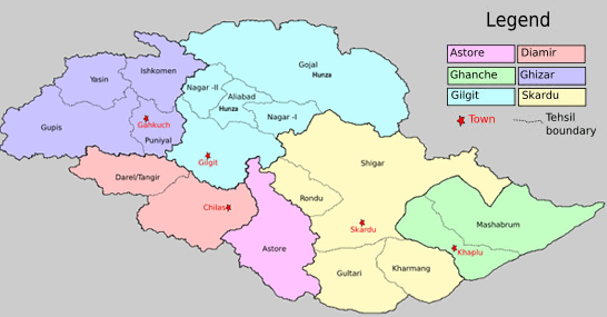
Places Of Interests In Gilgit Baltistan
Gilgit
Just 10 kms from the town of Gilgit, is a Buddha carved into a stone face. Buddha is a victory monument of Taj Mughal, built 700 years ago. The beautiful valley of Naltar in the south eastern side of Gilgit is 35 km away from the main town. It’s lush green pastures and green carpeted ground make it a jewel of the Gilgit. It is a forested (pine) village known for its wildlife and magnificent mountain scenery.
Ghizer
Ghizer is North most part of Gilgit Baltistan. It is multi ethnic district and four major languages are spoken. Shina, Khowar, Burushaski and Wakhi. Ghizer offers scenic beauty is famous for treking & trout fishing.
Diamer
Diamer is the district where the Karakoram Highway enters to the Gilgit from the NWFP. Chilas is the capital of Diamer district. Diamer is famous by it’s pine forest. Pine wood is used in good quality of furniture.
Hunza Nagar
Hunza Nagar one of beautiful place in region. It offers historical view of Altit Fort, Baltit Fort, Ganish fort and skyscraper mountains. It’s covered by high peaks namely Rakaposhi (7,788 m), Ladyfinger (6,000 m) and Darmyani Peak (6,090 m) and Lady Finger mountains. In Hunza three major languages are spoken, Shina in Lower Hunza, Burushaski in Central Hunza , Wakhi in Upper Hunza and Burushaski in Nagar..
Nager Valley is very famous for hunting animals such as Marco Polo sheep, brown bears, show tigers etc. Gulmet, Faker and Bar are the popular tourist attraction places in Nagar. Golden peak Rakahposhi is situated in the Nagar Valley.
Ghanche
Ghanche is the easternmost district of the Gilgit.The capital of Ghanche District is Khaplu. This is the coldest place in Pakistan. Ghanche borders the Ladakh region of the Indian-held Kashmir and has two military fronts Siachin and Kargil.
Astore
Astor lie at the junction of several mountain routes, providing ample and varied trekking opportunities, including many short walks through this beautiful area. Tracks head eastwards from the Bulashbar area, up towards the wild but beautiful Deosai Mountains and Plains. To the north west, a trekking route leads to the Muthat Pass and continues on to Fairy Meadow. In the southwest, Rupal valley provides numerous opportunities for short and long treks. Rama lake is a must see!
Baltistan
Baltistan is extremely mountainous region. The second highest peak K2is situated in Baltistan. In Baltistan are fourteen highest peaks which attracts tourists. Glacial lakes are abundant in Baltistan and are of high touristic value.


